
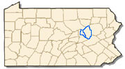
Region
Location
Driving distances:
Philadelphia - 135 mi.
Harrisburg - 77 mi.
New York City - 147 mi.
Columbia and Montour counties are located in Northeastern Pennsylvania. Interstate 80 intersects both counties and offers close North/South connections to Interstates 180 and 81. State Route 11 also parallels the North Branch of the Susquehanna River through the two counties.
The area's largest employers are Geisinger Health System, based in Danville, and Commonwealth University - Bloomsburg.
FACTS & FIGURES
Columbia County
Land area in square miles: 483
Persons per square mile: 139.7
Urban population percent: 59.2%
Rural population percent: 40.9%
Current Columbia County Profile
Montour County
Land area in square miles: 130
Persons per square mile: 140.5
Urban population percent: 46.2%
Rural population percent: 53.8%
Current Montour County Profile
Center for Workforce Information and Analysis, PA Dept of Labor and Industry, & U.S. Census Bureau
Advance Central PA, the regional workforce board, can provide the most up-to-date wage rate information. Contact William Berry, Research Analyst, at 570-568-6868 or wberry@advancecentralpa.org.